Category Archives: Travel

Patagonia 2013: Local flavors of Chile

One of several posts from Patagonia.  The first one is here.  The best pics are here.  The coolest experience was here.  More to come.

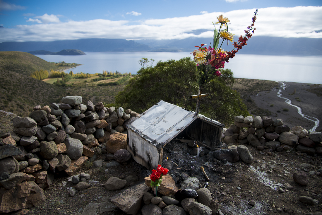
Along the roadsides of southern Chile and Argentina, you’ll see smallish “shrines” honoring national folk heroes, favorite or patron saints, and highway fatality victims.  Some of these shrines are tiny, like a birdhouse.  Some are big enough to walk inside.  As cars drive by, they often honk their horns, apparently in honor of the saint, hero or loved one for whom the shrine was built.

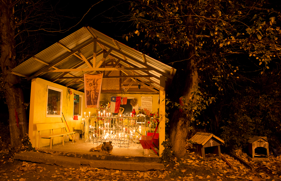
The doghouse-sized shrine above is on a tiny turnout from a winding road on the hill above Lag0 Gen. Carerra, near the Chile/Argentina border.  It appears that this one honors a dead “loved one.”  Notice the two candles — burning mid-day on a Tuesday.  The garage-sized shrine below honors San Sebastian, one of Chile’s patron saints.  Notice how many people had left candles!!  The dog seemed to live there (alongside a major highway), in his own guardian shack next to the shrine.  He was friendly when we arrived, but barked when we left without giving him a snack.


_JC88833.jpg_JC88838.jpg

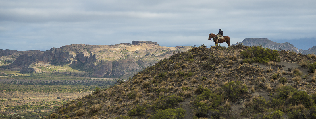
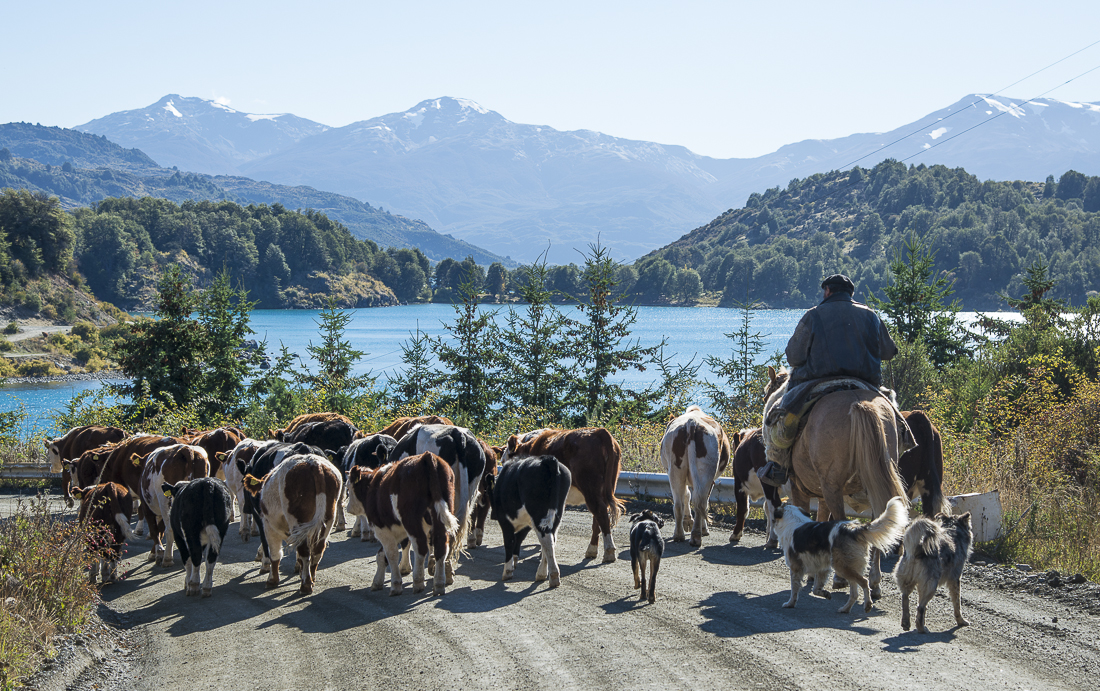
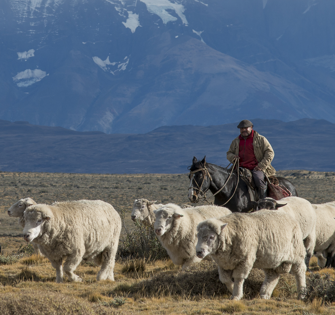
It really is true that Chilean men wear berets — especially when they’re working outdoors or with animals.  It’s the Chilean equivalent of a cowboy hat.  Chile was quite “modern” in many respects (we had WIFI everywhere except the actual “wilderness” of a National Park), but even so, you’re likely to encounter a small group of cattle, sheep or horses being herded right down the middle of a major road.  Occasionally there were road signs prohibiting such herding of animals on the highway.

_JC88775.jpg_JD82221.jpg

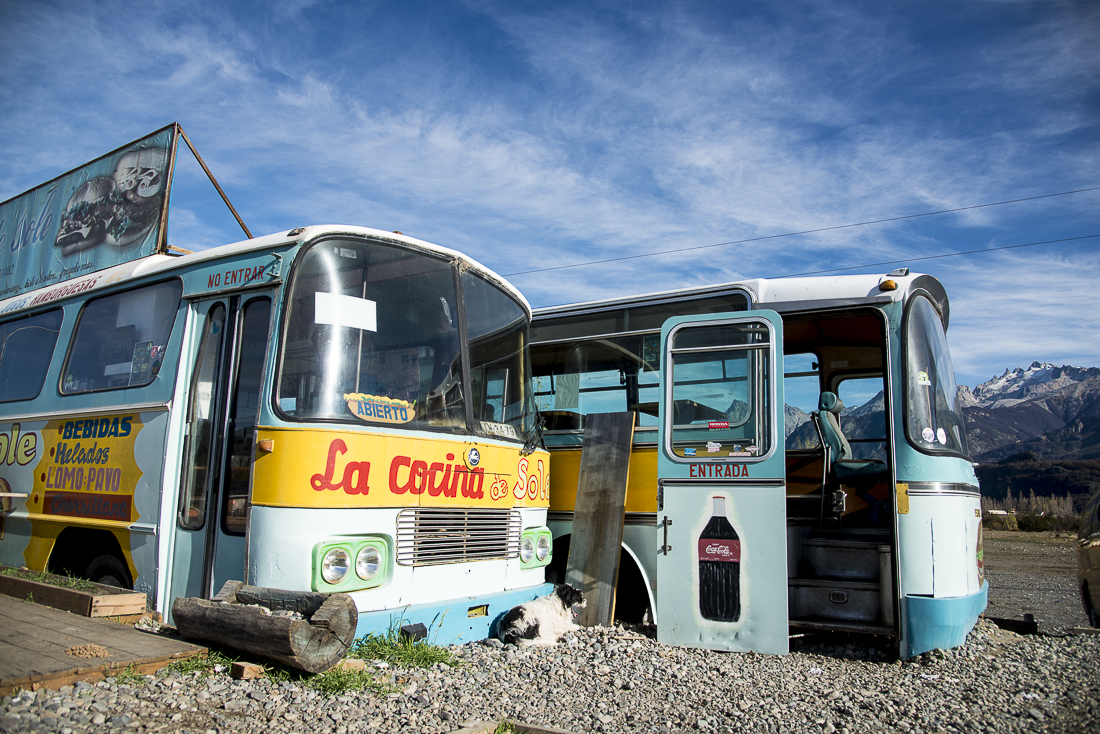
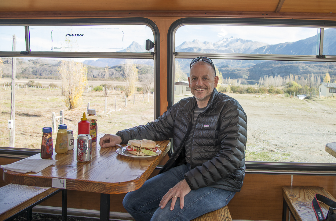
Notwithstanding Chile and Argentina’s famous beef, lamb and wines, Mike Short’s favorite restaurant consisted of two former city buses (sans wheels) stuck next to one another.  Big sandwiches.  My favorite part of La Cocina de Sole (I can’t figure out the translation?) was the moment when its two Chilean proprietor/cooks were in the kitchen singing “Don’t Cry for me Argentina.”  I suspect it means something different to them than it did to me (or to Andrew Lloyd Webber) — they were about 15 miles from the Argentine border.  Mike got the mesa next to the window.

_JC88865.jpg_JC88870.jpg


Patagonia 2013: Trekking the “W” at Torres del Paine

One of a group of posts from an”autumn” trip to Patagonia. 


If you just drive around Torres del Paine National Park in far-southern Chile, you’ll be very impressed.  But “you ain’t seen nothin'” unless you’ve hiked deep into the park, where the weather, the trees, the lakes, the peaks — everything — is completely different.  One of the two famous “Treks” around the iconic mountains is called the W; each prong of the W-shaped route probes into one of the valleys of the park.  You start in arid scrub at the edge of the park, go up and down through multiple climate zones and cloud layers, and wind up shivering next to a bright-blue glacier.

It’s a multi-day trek.  We were fortunate enough to get to stay in “refugios” — essentially bunkhouses (with meals!) in the wilderness at the bases of the W — rather than having to camp.  We even met a few new friends along the trail and at the refugios.  All in, it was nearly 30 hours of “trekking” over 4 days, often in rain or wading through creeks and flooded trails.  We got some of the nastiest blisters you’ve ever seen.

The red building (and the one with the rainbow) is the hotel at the far east edge of the W, where the trek began.  The tall granite spires are the actual Torres (towers) del Paine themselves.  The interior shot is at Refugio Cuernos.  The W trek ended at the north end of Lago Grey, near where the Grey Glacier dumps into the lake.  We were able to catch a Glacier boat back to civilization at the end of our trek — saving us several hours of backtracking.  The last shot at the bottom is where we got off that boat.  That’s a real condor circling above near the cliffs.


Patagonia 2013: Argentina’s Mt. Fitz Roy (“El Chalten”)

Part 2 of a series that started here:  Argentina’s Mt. Fitz Roy (“El Chalten”) wasn’t actually the first stop on my Patagonian adventure, but these are some of my favorite pictures, and (unlike the others) I’ve sorted through them and they’re ready to go.  Much more later.


My weeks in Chile and Argentina’s Patagonia region are almost over.  Lots of good pictures – though as always, the perfect image eludes me.  It’s fall here, so the weather is unpredictable and there were lots of gray skies.  The tradeoff is that the leaves are changing, giving us a view of Patagonia most of the ‘summer’ (November – February) tourists never see.  It’s very quiet – the restaurants and the trails are mostly empty.

To get north out of far-southern Chile, you’ve got to go into southwestern Argentina.  Chile is so mountainous there are no Chilean roads that connect its southernmost section with the rest of the country.  Thus as we headed north, we crossed into Argentina for a few days.

The real highlight of the Argentinian section was Mount Fitz Roy (known locally as El Chalten).  Amazingly, you could see El Chalten for over 100 miles as we drove towards it.  All the pictures on this post are of (or around) Mt. Fitz Roy).


_JC88341.jpg_JD82534.jpg_JD82594.jpg_JD82621.jpg_JD82657.jpg_JD82833.jpg_JD82893.jpg_JD82983.jpg_JD83136.jpg_JD83298.jpg_JD83381.jpg

The trip into Argentina had other highlights:  A great steak.  Some Argentine wine.  Up-close views of a glacier or two.  Me teaching my friend Mike Short to play craps in a small-town Argentinian casino.   Going 575km between functioning gas stations in a car with a range of 580km (apparently).

Cristina Fernández de Kirchner on the throne

This was the photo on the wall. Argentine President Fernandez. Scepter, sash, lace & throne.

Our introduction to Argentina was driving through immigration and customs at a rural border crossing.  Picture a tiny isolated home, with nothing for miles around, and with half-finished concrete construction work on the front porch and sidewalk.  You just park somewhere out front and walk through the yard to go in.  Inside you’re “welcomed” by Sgt Lopez and by a portrait of Argentine President  Cristina Fernandez.  President Fernandez is literally sitting on a throne, holding a scepter and wearing a sash and a lace dress.  She looks like a sixty-year-old prom queen, shot with a her mom’s cheap cameraphone.  Still, the sign says she welcomes us to Argentina – which is nice.

Lopez is more discriminating about who he welcomes and who he doesn’t.  He’s dressed in full military drab – a green wool uniform probably left over from the 40s, complete with a perfectly round but perfectly flat hat that looks like a green tambourine with a black bill.  Makes me want to call him “Generalissimo” and chat him up about the Falklands War.  The hat sits on the desk as he grumbles his way through our paperwork, including a few disgusted “Aye aye ayes.”  He rummages through a desk drawer to find the proper forms for two Americanos crossing the Chile/Argentine border in a rented SUV.  He finds one – just one – and rips apart the duplicating pages so each of us can fill one out.  He seems to want some sort of “carta” (“letter, card, or document”?) that we clearly do not have.  He shakes his head (“AYE aye aye”) and gets over it.

On the other side of the room is the much friendlier customs guy.  His job, apparently, is to write down in big old-fashioned manual ledger books the license number of our car and the passport number of the driver.  There are stacks of these log books; I’m sure they will never be opened again for any purpose whatsoever.  Behind him is the biggest (and perhaps most important) section of the facility:  the ping pong table.  There are probably some very long lonely stretches between cars out here.

Never are we even asked if we had weapons, drugs, passengers, diseased fruits and vegetables, or anything else. (We did not, fyi).

We make it through.  Critically:  At no time during this process did I bust out laughing.  But I wanted to.


On the road again! Patagonia 2013

I guess my ‘hiatus’ from travel (and thus from travel blogging) is over.  As some of you out there know, I had one last lawsuit to finish up in my legal career, so in December I rejoined the great team I’ve worked with for the last decade and wrapped up a ten-year-old case that has changed all our lives.  We’re done!  That last chapter (our claims against Swiss investment bank Credit Suisse) is reported here if you’d care to see the story.  I may still find a time to be teary-eyed again about not being around those dear friends and great lawyers with whom I had the privilege to practice — but now is not the time for that.

So I’m back on the road.  Step one was to fly to Punta Arenas, Chile, which is as far south as one can fly and still be on the “mainland” of South America.  Here’s the best picture of the day — honestly, it doesn’t look like much.  This shot — like Punta Arenes generally — looks across the Strait of Magellan at the islands of Tierra del Fuego — the jumble of islands that cap the bottom of the continent.  Actually this was about 30 miles south of Punta Arenas — “about as fer as you can go.”

But the real sights of this region — called “Patagonia” and including the iconic Torres del Paine — are for the weeks ahead.  It’s not as cold or as exotic as you’d think down here.  But we’re just getting started.  Not sure how consistently I’ll be able to get wifi access in the days ahead, but hopefully the weather will allow some decent pictures I can post in the weeks ahead.

 25 miles south of Punta Arenas, Chile, overlooking the Strait of Magellan and the islands of Tierra del Fuego


Paris 2012: A History Lesson

Here’s the last of three posts from a great trip to Paris with my niece Caitlin and sister Jana.

I had to brush up on some superficial French history  just to grasp some of what I was seeing in Paris last week, and to fit it in with a little perspective.  Here’s the crash course:

France had a series of Kings from the 5th Century through the 18th Century.  After 1610, they were all named Louis.  They lived in the Louvre (then a Palace) in Paris until the the 1680s when they moved 10 miles outside of town to a huge estate and a new palace at Versailles (now a Paris suburb).  Versailles served as the royal residence and center of most government until the late 1700s.  In 1789, Louis XVI  and Marie Antoinette were reigning as King and Queen, which was very bad timing for Mademoiselle LetThemEatCake:  Louis and Marie were dragged out of Versailles by French Revolutionaries.  By 1793, the monarchy was done (mostly) and both Louis and Marie were guillotined in Place de la Concorde in the center of Paris.  Ouch.

After the big Revolution ended the centuries of rule by kings, it took the French about one decade to appoint, instead, an Emperor!  Pope Pious VII (go figure) presided over the coronation of Napoleon Bonaparte and his Empress, Josephine  in the 12th Century cathedral, Notre Dame (“Our Lady”) de Paris in 1804.  Napoleon ruled France from 1804 until he met his Waterloo — at Waterloo — in 1815.

The next several decades saw a mix of monarchs (Louis XVII, etc.) and an occasional return of Napoleon and/or his nephew (Napoleon III) as temporary emperors.  The famous  book/musical/movie, Les Miserables, was set (in Paris) in the early 1800s, during a period of monarchy (i.e., not during the French Revolution, as I’d always thought).  It was 1871 before a successsion of elected Presidents took over for good (sort of).  That was the era when the Parisians put up the Eiffel Tower.

It was Napoleon Bonaparte who commissioned the Arc de Triomphe to honor his military heroes and fallen soldiers.  Napoleon’s own body passed through the Arc on the way to his tomb.  The French marched around the Arc to celebrate their Triumph at the end of World War I; Hitler’s troops did the same when they took the city in 1940.  Happily the last big triumph along those lines was when our own American GIs (together with French and English Allied troops) liberated the city in 1944.  Their well-deserved celebration parade went around the Arc and down the adjacent avenue, the Champs Elysees to Place de la Concorde (toward the Louvre, where this story began).

_JC86003.jpg_JC85951.jpg_JC85441.jpg_JC85513.jpg_JC85546.jpg_JC85554.jpg_JC85578.jpg_JC85398.jpg_JC85940.jpg_JC85393.jpg_JC86023.jpg_JC86035.jpg_JC86045.jpg_JC86062.jpg_JC86076.jpg_JC86085.jpg_JC86091.jpg_JC86101.jpg_JC86120.jpg_JC86150.jpg_JC86161.jpg_JC86663.jpg

The big archway (pictured at night) is, of course, the Arc de Triomphe; the traffic pictures are from the precarious middle of the Champs Elysees.  The ferris wheel was set up at Place de la Concorde.  You probably recognize the church facade as Notre Dame.  The greenish statutes, the lavish landscaping, and the fancy chandeliers are at Versailles.  The pretty girls are my sister and niece. 


A PHOTOGRAPHY LESSON / EXPERIMENT :

For camera ‘folk’:  For the shot of the Arc in twilight, I quickly realized couldn’t get the cars out of the picture.  At faster shutter speeds, it looked like a parking lot of oddly-spaced cars.  To blur the cars, I adjusted ISO and f-stop ’til my shutter speeds were around 1/4 or 1/6 second.  Handheld.  The VR (Vibration Reduction — same as Canon’s Image Stabilization) elminated the blur on the stationary arc, but doesn’t (couldn’t) eliminate the blur on the moving cars.  Though the cars are blurred beyond recognition, I was surprised how sharp the VR system kept the Arc itself.  The picture (below) on the right is just a cropped section of the one on the left — notice that you can read the inscriptions on the Arc.  If I had it to do over, I’d have left the f-stop wide open and improved my ISO instead.

c85-_JC86003.jpg_JC86003-2.jpg