Category Archives: Landscapes

Patagonia 2013: Trekking the “W” at Torres del Paine

One of a group of posts from an”autumn” trip to Patagonia. 


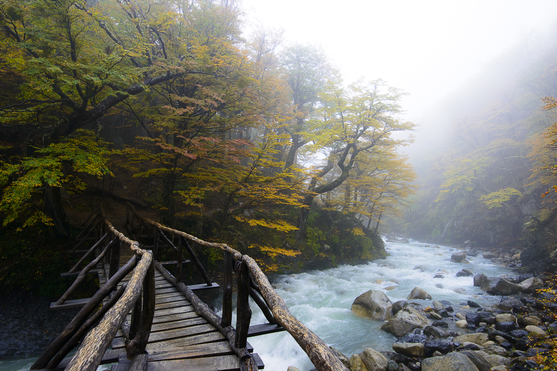
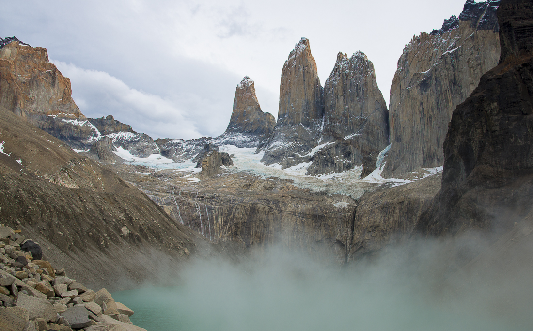
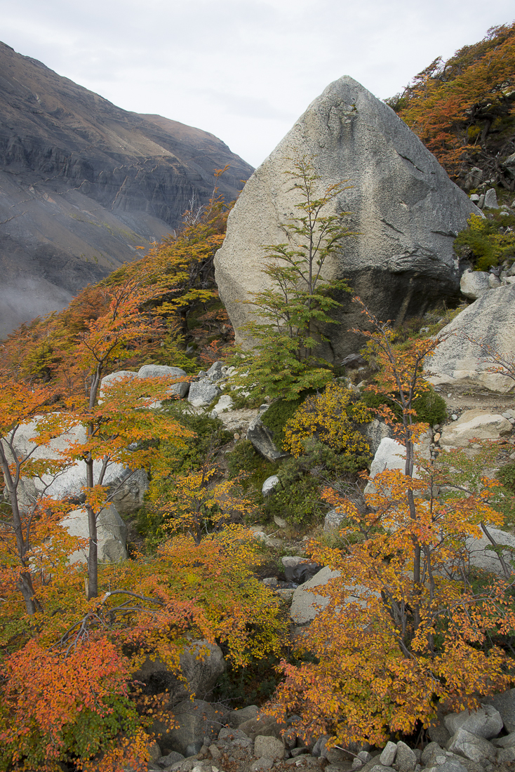
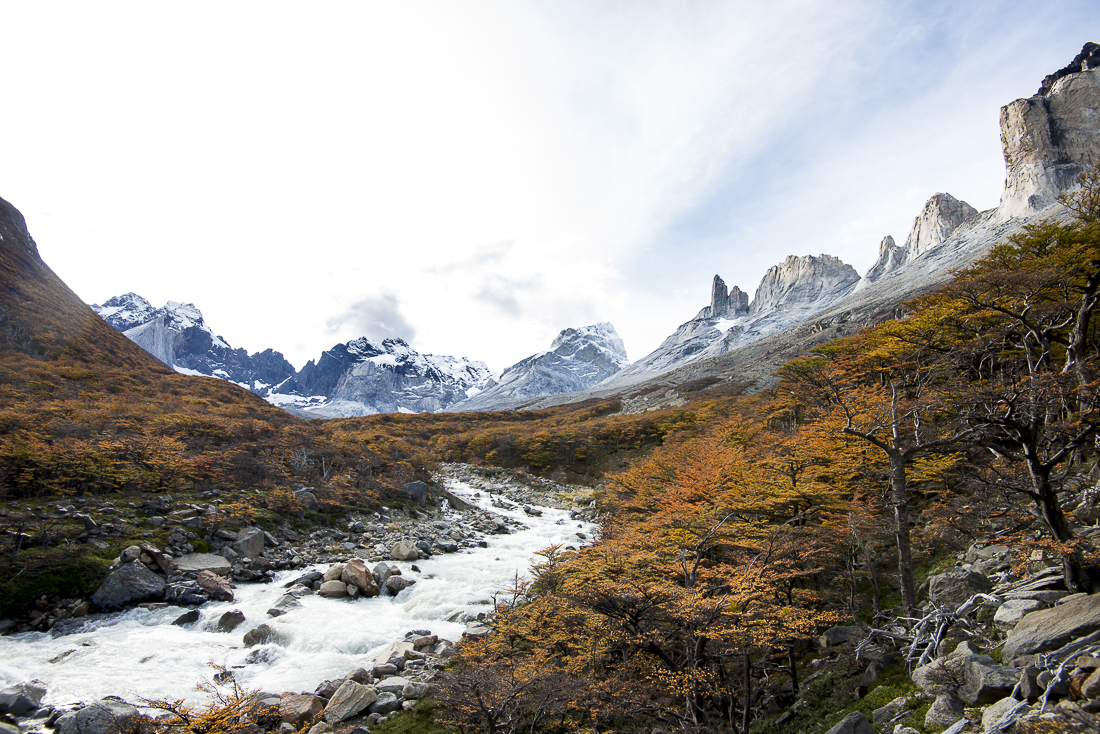
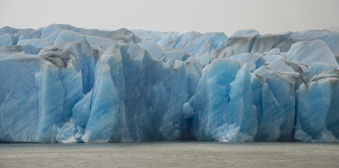
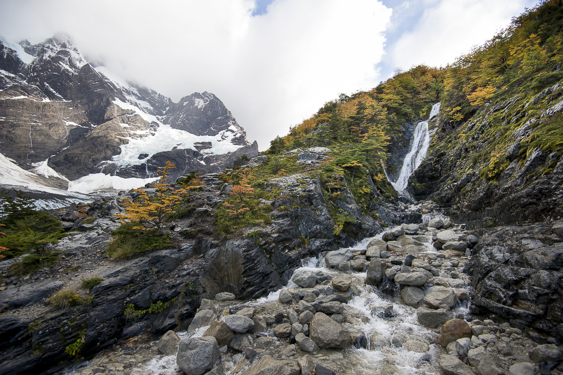
If you just drive around Torres del Paine National Park in far-southern Chile, you’ll be very impressed.  But “you ain’t seen nothin'” unless you’ve hiked deep into the park, where the weather, the trees, the lakes, the peaks — everything — is completely different.  One of the two famous “Treks” around the iconic mountains is called the W; each prong of the W-shaped route probes into one of the valleys of the park.  You start in arid scrub at the edge of the park, go up and down through multiple climate zones and cloud layers, and wind up shivering next to a bright-blue glacier.

It’s a multi-day trek.  We were fortunate enough to get to stay in “refugios” — essentially bunkhouses (with meals!) in the wilderness at the bases of the W — rather than having to camp.  We even met a few new friends along the trail and at the refugios.  All in, it was nearly 30 hours of “trekking” over 4 days, often in rain or wading through creeks and flooded trails.  We got some of the nastiest blisters you’ve ever seen.

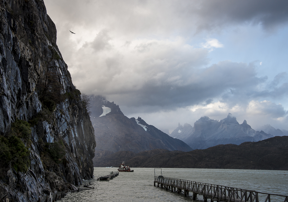
The red building (and the one with the rainbow) is the hotel at the far east edge of the W, where the trek began.  The tall granite spires are the actual Torres (towers) del Paine themselves.  The interior shot is at Refugio Cuernos.  The W trek ended at the north end of Lago Grey, near where the Grey Glacier dumps into the lake.  We were able to catch a Glacier boat back to civilization at the end of our trek — saving us several hours of backtracking.  The last shot at the bottom is where we got off that boat.  That’s a real condor circling above near the cliffs.


Patagonia 2013: Argentina’s Mt. Fitz Roy (“El Chalten”)

Part 2 of a series that started here:  Argentina’s Mt. Fitz Roy (“El Chalten”) wasn’t actually the first stop on my Patagonian adventure, but these are some of my favorite pictures, and (unlike the others) I’ve sorted through them and they’re ready to go.  Much more later.


My weeks in Chile and Argentina’s Patagonia region are almost over.  Lots of good pictures – though as always, the perfect image eludes me.  It’s fall here, so the weather is unpredictable and there were lots of gray skies.  The tradeoff is that the leaves are changing, giving us a view of Patagonia most of the ‘summer’ (November – February) tourists never see.  It’s very quiet – the restaurants and the trails are mostly empty.

To get north out of far-southern Chile, you’ve got to go into southwestern Argentina.  Chile is so mountainous there are no Chilean roads that connect its southernmost section with the rest of the country.  Thus as we headed north, we crossed into Argentina for a few days.

The real highlight of the Argentinian section was Mount Fitz Roy (known locally as El Chalten).  Amazingly, you could see El Chalten for over 100 miles as we drove towards it.  All the pictures on this post are of (or around) Mt. Fitz Roy).


_JC88341.jpg_JD82534.jpg_JD82594.jpg_JD82621.jpg_JD82657.jpg_JD82833.jpg_JD82893.jpg_JD82983.jpg_JD83136.jpg_JD83298.jpg_JD83381.jpg

The trip into Argentina had other highlights:  A great steak.  Some Argentine wine.  Up-close views of a glacier or two.  Me teaching my friend Mike Short to play craps in a small-town Argentinian casino.   Going 575km between functioning gas stations in a car with a range of 580km (apparently).

Cristina Fernández de Kirchner on the throne

This was the photo on the wall. Argentine President Fernandez. Scepter, sash, lace & throne.

Our introduction to Argentina was driving through immigration and customs at a rural border crossing.  Picture a tiny isolated home, with nothing for miles around, and with half-finished concrete construction work on the front porch and sidewalk.  You just park somewhere out front and walk through the yard to go in.  Inside you’re “welcomed” by Sgt Lopez and by a portrait of Argentine President  Cristina Fernandez.  President Fernandez is literally sitting on a throne, holding a scepter and wearing a sash and a lace dress.  She looks like a sixty-year-old prom queen, shot with a her mom’s cheap cameraphone.  Still, the sign says she welcomes us to Argentina – which is nice.

Lopez is more discriminating about who he welcomes and who he doesn’t.  He’s dressed in full military drab – a green wool uniform probably left over from the 40s, complete with a perfectly round but perfectly flat hat that looks like a green tambourine with a black bill.  Makes me want to call him “Generalissimo” and chat him up about the Falklands War.  The hat sits on the desk as he grumbles his way through our paperwork, including a few disgusted “Aye aye ayes.”  He rummages through a desk drawer to find the proper forms for two Americanos crossing the Chile/Argentine border in a rented SUV.  He finds one – just one – and rips apart the duplicating pages so each of us can fill one out.  He seems to want some sort of “carta” (“letter, card, or document”?) that we clearly do not have.  He shakes his head (“AYE aye aye”) and gets over it.

On the other side of the room is the much friendlier customs guy.  His job, apparently, is to write down in big old-fashioned manual ledger books the license number of our car and the passport number of the driver.  There are stacks of these log books; I’m sure they will never be opened again for any purpose whatsoever.  Behind him is the biggest (and perhaps most important) section of the facility:  the ping pong table.  There are probably some very long lonely stretches between cars out here.

Never are we even asked if we had weapons, drugs, passengers, diseased fruits and vegetables, or anything else. (We did not, fyi).

We make it through.  Critically:  At no time during this process did I bust out laughing.  But I wanted to.


Fall Leaves in the Upper Rio Grande

Ever wonder where the Rio Grande got its start?

_JC89449

If you follow the Rio Grande upstream about as far as it goes — to where the Rio Grande is still a rio muy pequeño — you’ll wind up a little west of Creede, Colorado.   Fortunately, most Colorado tourists have overlooked this area because it’s a long way from major airports and ski resorts, but there’s a loyal Texas and Oklahoma crowd that usually arrive in RVs for riverside camping, or in 4-wheel-drive vehicles for exploring the mountains.

It’s a great place year-around, but — until last week — I’d never been there for the real “peak” color of the aspen leaves in the fall.  They’re beautiful, but they’re quick!  In the space of a week, lots of the a

spen leaves went from green to gone.  Fortunately, I got a few pictures before they all disappeared.

———–

If you want to see several more fall leaves shots, OR if that slideshow above doesn’t work on your browser or device, click here to see them on a different page.

————

Pine beetles are a constant scourge in Colorado, and a few years back a wave came through and killed a bunch of trees.  The locals call it “Beetle Kill.”  The bugs eat the mature evergreens but don’t touch the aspen.  Lots of the pictures have at least a few obvious dead trees.  The shots below are of areas where the evergreens are essentially wiped out.  It looks as though the aspen will quickly take over the open space.


Great Sand Dunes National Park

Quick:  Where are the tallest Sand Dunes in North America?   Hint:  They’re not in a desert, or at a beach.  The Answer:  Southern Colorado — surrounded on all sides by the Rocky Mountains.    Somehow a combination of prevailing winds, mountain winds, and the sandy remnants of an extinct high-altitude lake have formed a 30 square mile sand dune field just west of the Sangre de Cristo Mountains east of Alamosa, Colorado.  The big dunes rise over 700 feet above the surrounding terrain — roughly the height of a 60-story building.  (Notice the tiny little people way up on the top).

I was en route from Leadville to Houston recently, and detoured a few miles to see the Great Sand Dunes National Park and Preserve.  I didn’t expect much, but it was actually more interesting-looking than I’d imagined.  Unfortunately, heavy cloud cover made the light flat and limited the photographic possibilities.  Then some approaching lightning convinced me that I’d picked the wrong day to climb up on the high, isolated dunes.


The National Park Service’s descriptions say the former gigantic Lake Alamosa disappeared due to “climate change,” but the change to which it refers is not one caused by my Chevy Tahoe or the plastic bottles from which I drink Diet Coke.  Apparently it happened a few hundred thousand years ago, so I have a pretty good alibi. 

Rocky Mountain Highest: Leadville, CO

I’ve been without a WIFI connection for a couple of weeks!  Forgive the delayed posts.  If you want a follow-up about the burro racing, go here


If you’re looking for America’s highest post office, head for Leadville, Colorado —  America’s highest town.  Depending on just what and where you measure, it’s around 10,200 feet in elevation.  The town also boasts (literally) the country’s highest airport.  Mt. Elbert, the highest peak in Colorado (14,440 ft), looms over the south side of town; Mt. Massive (the second highest at just 14,428) is just west of town.  Around here, thin air and isolation are selling points and badges of honor.

There’s plenty of evidence in Leadville of a past that was both grander and rougher.  The town started in the 1800s as a mining “boom” town.  It’s just got 3,000 or so people now, but it allegedly had 10 times that population (and 100 saloons!?!) in the 1880s.  Back then Oscar Wilde lectured in the city’s Tabor Opera House (probably with Leadville residents (unsinkable) Molly Brown and maybe Doc Holiday in the audience).  At the same time, thousands of men braved sub-zero temperatures, using mule and muscle to drag tons of silver-laden ore out of the mines that surround the city.


130 years later, there’s still a lot going on in now-tiny Leadville.  The first weekend in August was “Boom Days,” celebrating Leadville’s past with gritty mining competitions (see the jackhammer and sledgehammer pictures) on one end of downtown and a lacy Victorian costume contest on the other.  These are two very different crowds.  Meanwhile, a 22-mile pack burro race shut down Highway 24 through the middle of town.  This being Colorado — there’s always a laid-back “hippie” crowd around town, too, and on most summer days there are a dozen or so leather-shrouded Harley riders cruising the streets.  Talk about diversity.

Yet another crowd (this one with spandex shorts, carbon fiber bikes, and Gatorade) swarms the town in the summer, gearing up for  arguably the biggest mountain bike race in the country – the Leadville MTB 100 “Race Across the Sky”.  Like the Leadville Marathon I did a couple of months back, it starts at 10,200 feet and generally just goes higher and higher from there.  That’s why I was in town, along with a half dozen or so good friends.  More news on the bike race in a day or so when the pictures get compiled.

Topping it all off, camped out west of town were none other than Joyce and J.B. Cotner (my mom and dad!).  One day when we were doing a practice ride of the toughest climb on the bike race course (climbing up to Columbine Pass at 12,400 ft), there sat Mom and Dad at the summit on a red ATV, waiting for us.  To say that my Mom and Dad are troopers would be a terrible understatement.  I’d convinced my Dad to come to Leadville by telling him we needed to come up with a strategy to win next year’s burro race (me as runner, him a burro trainer).   Crazier things do happen — especially in Leadville.

In the photo grid above:  The big green rock is part of the mining competition.  Yes, that’s an attractive young woman operating the 120 lb. jackhammer.  Do not mess with her.  The two-man sledgehammer (“double jack”) competition requires more trust in one’s teammate than I have for any of my friends — no offense guys.  The two men in the sledgehammer pictures apparently set an unofficial state record — chiseling a 27-inch hole in 10 minutes.  You don’t ride the burros in the burro race — you lead/push/drive/drag them 22 miles.  The winner makes it back to town in about four hours.  Apparently Leadville is the second leg of Colorado’s “Triple Crown” of pack burro racing.  That’s my Mom and Dad above (in red and blue) downtown watching the burro race and parade.  And that’s also them with me (bottom) behind their ATV at the top of Columbine; they’re showing off their preferred means of high-mountain transport and I’m showing mine.  If you pay attention to such things: I do have a fabulous bike (Specialized Epic S-Works 26; full suspension and weighs less than many road bikes) — because I need all the help I can get. 

I threw in some shots of the mountains around Leadville.  I didn’t really dedicate the time it takes to get really good mountain photos (scouting locations then waiting on perfect weather and light), so these do not do Leadville justice in the “majestic views” category.  Hopefully you can still get a sense of the landscape. 

(Bottom photo by Peter Thomsen, using whatever little camera he’d stuffed into his bike jersey).